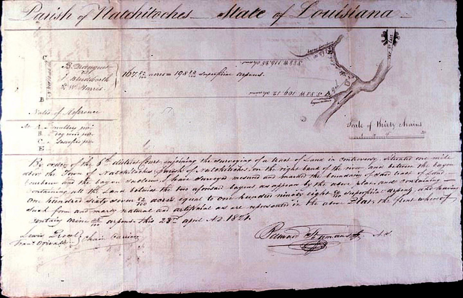
Mapa que se encuentra en el Louisiana State Museum Map Database por el que se puede constatar; que Benjamin tenía conocimientos de agrimensor (era persona con estudios) y que tuvo que luchar duro para ganarse la vida, puesto que este mapa se realizó para documentar la controversia que tenía con el Coronel James Budworth, comandante del regimiento de la compñía donde Benjamin prestó su servicio militar durante la guerra de 1812
|
Image: |
1983.001.005.jpg |
|
Title: |
Plan of the Land in Controversy B. Dranguet vs. J. Bludworth & Wm. Harris. |
|
Sub-Title: |
|
|
Verso-Title: |
|
|
Inset(s): |
|
|
Mapmaker: |
St. Amant, Bernard |
|
Publisher: |
|
|
Date: |
1821 Apr 23 |
|
Place of Publication: |
Natchitoches, La. |
|
Subject: |
Natchitoches, Bayou Bourbeaux, Bayou Sableaux; cost to survey land; B. Dranguet,. J. Bludworth, William Harris. |
|
Size: |
8 1/4 x 13 |
|
Medium: |
Manuscript, pen and ink |
|
Notes: |
Includes notation that the land is "situated one mile above the Town of Natchitoches, Parish of Natchitoches, on the right bank of the river and between the bayou bourbeax and the bayou sableaux, I have Surveyed, measured and marked the boundaries of said tract of land, containing all the Land between the two aforesaid bayous, as appears by the above plat, and containing one hundred sixty seven 82/100 acres, equal to one hundered ninety eight 84/100 superficial arpens, and having such form and marks natural and artificial as are represented on the abov Plat, the front whereof containing nine 45/100 arpens." Verso: itemized list of fees charged by the surveyor. Includes costs for cost for chain carrier, mileage, drawing the plat.[1] |
|
Accession Number |
1983.001.005 |
[1] Incluye la indicación de que el terreno está "situado a una milla por encima de la ciudad de Natchitoches, Parroquia de Natchitoches, en el margen derecho del río y entre el afluente arenoso y el afluente cenagoso, he inspeccionado, medido y marcado los límites de dicha extensión del terreno, que contiene toda la Tierra entre los dos arroyos antes mencionados, como aparece en el plano catastral superior, y que contiene ciento sesenta y siete 82/100 acres (Aprox. 67,5 Hectáreas), equivalente a ciento noventa y ocho 84/100 arpens de superficie, y lo forman las marcas naturales y artificiales representadas en el plano catastral superior, cuyo frente es de nueve 45/100 arpens ". En el reverso: lista detallada de los derechos cobrados por el agrimensor. Incluye los costos del “porta cadenas”, el kilometraje, elaboración del plano catastral.